Since moving to Oregon, I’ve become a big fan of the state. It’s full of amazing places to see, has comfortable and interesting weather, and yes, has awesome people.
That said, I can’t really say much about me “moving” here – especially since it was from California. People in Oregon (as you can read below), tend to not have the fondest sentiments toward us southern dwellers.
Nevertheless, the locals are easy to get along with, and it’s made me more and more interested in planting myself here for some time. In considering this, I found myself curious about the different climates of Oregon. I’ve been to Bend, Ashland & surrounding areas of Southern Oregon, and the coast all many times (I now live in Vernonia, at the edge of the Coastal Range, just west of Portland).
One thing really struck me: All of these places are different. Like, very different.
And this got me looking around for answers. And then I found one.
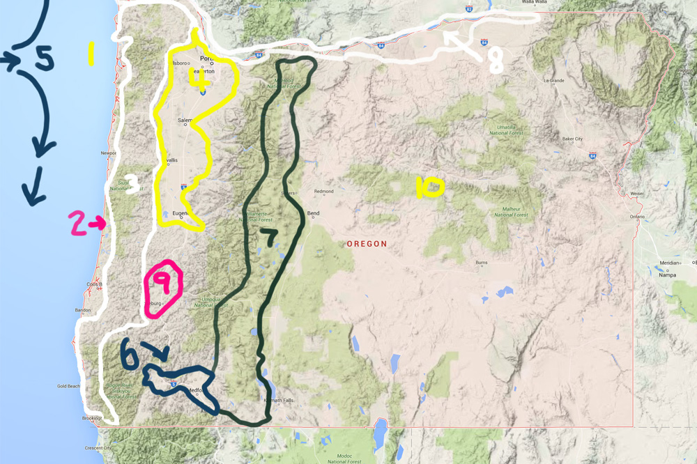
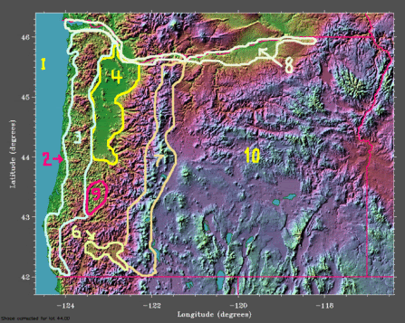
Back to 2006, a gentleman by the name of ‘Steve’ posted a breakdown of the climate zones and one of the climate patterns here in the PNW (see the original post). He sketched an Oregon Climate Map, and I thought it was both interesting and useful.
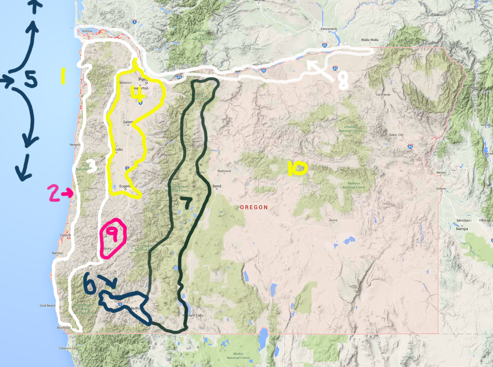
The one problem: the image was tiny and I wanted to see city names. So, I’m republishing Steve’s work with a new map (click to enlarge), some extra links in the body of his work, and a few grammar corrections (sorry, Steve).
With the map, city names are somewhat hidden by lines, but it’s much easier to see where these zones start and end – at least I hope.
Also, if you’re thinking about how this relates to farming/growing, here’s a guide on growing fruit trees in the Pacific Northwest and a plant hardiness map of Oregon.
The Revised Oregon Climate Map
[Updated Image: Map Credit to Google Maps]
This post is intended for flatlanders, head-in-the-clouds utopia-seekers, rat-race shirkers, economic refugees from California and others who think that all of Oregon is just one continuous forest of green. The parts of the state that actually conform to that stereotype are those that are shown below in green. The blue/purple two-thirds of the state to the East are dry sagebrush/juniper rangelands with or without nearby mountains. Hopefully this will help to explain the climatic tradeoffs and why there is no “Goldilocks climate” in Oregon. Here are my notes:
1. The North Pacific High: The North Pacific High Pressure System begins to build in May and is usually at full stability by the beginning of July. This keeps moisture from the Pacific from moving inland, giving Oregon very dry summers. Occasionally the southern or eastern parts of the state will get brushed by a rogue thunderstorm from the interior of the continent, but generally there is no measurable precipitation in Oregon from June-October. The NPH begins to weaken in September, and by late October, moisture-laden winds are able to move on shore.
2. The Coastal Strip: A narrow bench between the Pacific and the Coast Range. Along the southern coast, the Siskiyou massif comes right down to the coast, leaving very little habitable land for towns. The coast is the most frost-protected part of the state, but it’s no Riviera. It’s the state’s coolest summer area, summer highs mostly in the upper 50’s to low 60’s. High wind and rainfall during the winter, episodic fog in the summer. Rainfall can be torrential in winter. Tourist and retirement-based economy.
3. The Coast Range: mountains that range up to about 4000 ft. elevation above the coastal strip. To the west, they bring morning (and sometimes all-day) fog in summer. To the east, they tend to keep marine influences out of the intermountain valleys during the summer. Very few people live in the Coast Range itself.
(JR Note: This is split in 3 separate zones, the Northern, Central and Southern Coastal ranges.
4. The Willamette Valley: a broad river valley plain between the Coast Range and the Cascades. When out-of-staters make broad sweeping generalizations about “Oregon”, they are usually referring to this area. Winters are cloudy and rainy with moderate freezes at night. Rains are often light but long-lasting. Summers are pleasantly warm, sunny and dry. Most of the state’s population lives here. All Oregon’s major cities are in the Willamette Valley.
5. Five? Did I forget a five? I did, sorry! I’ll use it though, to mention the PDO. The Pacific Decadal Oscillation brings alternating relatively wet and relatively dry decades to Oregon. Summer drought becomes a real issue during the dry years. We’re somewhere in the middle of a wet cycle right now. In another 10-15 years, we’ll go back into a dry cycle.
(JR Note: Steve published this in July 2006. If he was right, we’re probably beginning our dry cycle in 2016. I also added a #5, seen in Dark Blue on the left side of the image above).
6. The Rogue River Valley: Most people, when they speak of “southern Oregon” are speaking of this area. Grants Pass, Medford and Ashland are the major population centers. Summers here are quite warm (temps over 95F are very common). Winters and springs are drier. An inversion layer is endemic to the valley and often causes summer haze from automobile pollution or heavy fog in winter. The area is a major fruit-production region.
7. The Cascades: Mountains up to 10,000 ft. wring the moisture out of the moist air coming off the Pacific. Winters to the west are rainy and cloudy. To the east, there is more sunshine and colder temperatures. Most of this area is under National Forest Service jurisdiction and few people live here.
8. The Columbia River Valley: The only real gap in the Cascades. Green to the West, rather dry to the East. A major transportation corridor and agricultural area. Oregon’s hottest summers are found here. Winters are mild to the west of Portland, and increasingly colder to the East. Portland is situated at the confluence of the Columbia and Willamette Valleys, but its climate is mostly Willamette.
9. The Hundred Valleys of the Umpqua: The region around Roseburg is intermediate between the Willamette and Rogue River Valleys. Summers are long and warm. Winters are quite mild. Economy is timber-based and volatile.
10. Central and Eastern Oregon: isolated from western Oregon by the Cascades. There is a different climate and different look to the land. Winters are colder and sunnier. The area is sparsely-populated and towns are often very far apart. This is mostly basin and range land, but western Oregonians commonly refer to it as “the desert”. Water availability has limited the potential for human settlement. The most affordable land in the state is here. The area around Bend has been booming for the past 20 years and is a popular recreation area. Housing affordability is not favorable around Bend due to the area’s popularity.


